What is a Living Shoreline?
Also known as “Living Reefs,” Living Shorelines are human-made and use natural materials to create a gentle transition between land and water in order to reduce erosion and support the local ecosystem. Often, they are composed of a number of stabilization measures and are designed to be incorporated into the ecosystem for longevity. Each Living Shoreline is unique, designed to target the specific issues of an individual ecosystem with solutions that draw on native plant and animal species and nearby topography. There are a series of Living Shorelines across the Northeast.
Why do we use Living Shorelines?
A primary purpose of a Living Shoreline is to stabilize the shoreline and prevent erosion. Their marshes and oyster reefs act as barriers, absorbing wave energy. These methods fare better against storms than bulkheads and other “hard” shorelines. Additionally, mussels and oysters work as filter feeders, improving water quality. Living Shorelines promote coastal biodiversity and preserve our land for decades to come.
Why do we need a Living Shoreline at Edith Read Wildlife Sanctuary?
A portion of the land surrounding the Edith Read Wildlife Sanctuary is human-made, built nearly a century ago. This makes this section of the coastline susceptible to erosion, especially in an area prone to hurricanes. Approximately 30 feet of shoreline has been lost in the last 10 years. There have been attempts to protect this vulnerable shoreline in the past, however these did not last. Adding a Living Shoreline is the most effective way to both work with the local environment and protect the area we know and love.
Who is Involved?
A team from SLR Consulting, familiar with the regional environment, has put together a plan for a Living Shoreline that addresses our community’s needs. The project is supported by Save the Sound, The County of Westchester, City of Rye, New York Department of Environmental Conservation, Soil and Water Conservation district Westchester and the County Departments of Planning and Public Works. Both Edith Read Wildlife Sanctuary and the Westchester County Parks Department have played a role in the planning phase of the project.
What will the Shoreline look like?
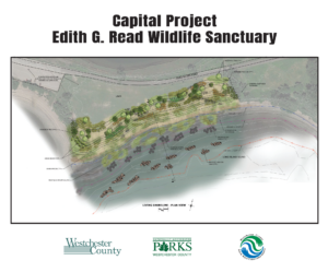
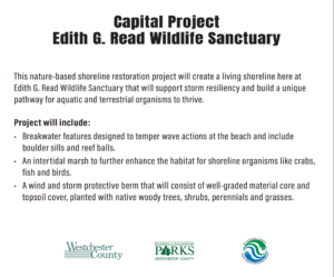
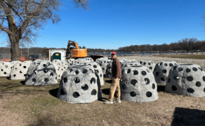
The Edith Read Living Shoreline implements a different strategy for each component of the shore. “Reef balls” and boulder sills will break up waves, reducing wave energy by 20 percent in regular conditions and up to 50 percent in extremely windy conditions. (See photo below.) It provides a structure for mussels and oysters to grow on, and after time they deteriorate and be replaced by colonies of these shellfish. In the intertidal zone, a marsh of native plants will further slow wave action and a gentle slope of shoreline will replace the steep drop. A dune-like backshore coastal berm will provide a final barrier. The grassy lawn behind this shoreline will remain largely preserved. A map of the intended design can be found below.
To learn more, check out the links below:
National Oceanic and Atmospheric Administration on Living Shorelines
SLR Powerpoint on Edith Read Living Shoreline Plan
The National Audubon Society on the Success of the Stratford Point Living Shoreline